 Albania
 Romania Offroad
 Slovenia
 Pyrenees Offroad
 Iceland Offroad
 Croatia
 Montenegro
 Morocco Offroad
 Tunisia
 Andalusia1 (Spain)
Bestellablauf (EN)
| User manual GPS data | |
|
Foreword: GPX off-road single route file: |
|
| What types of GPS are thereWhat types of GPS are there | |
 Species: Species:We have 3 types of GPS data (routes, tracks and POI/waypoints)Species:We have 3 types of GPS data (routes, tracks and POI/waypoints) What are routes: Routes have at least two points, a start and an end point. If, for example, the start is in Munich and the end is in Berlin, the sat nav calculates the route based on its settings (fastest, shortest, or most winding). There is a risk that this could result in incorrect routes; for example, if you want to drive via Nuremberg, a three-point (intermediate destination) Nuremberg is added. We tried to create a route with multiple points (intermediate destinations). The routes, as in the book, always begin with Route(s)_xxxx. If you drive the route in reverse from Berlin to Munich, the file is always called U_Route(s)_xxxxxx. The U_Routes only exist in part. What are tracks: Tracks are a series of points arranged in a line. Tracks are the best way to do this because they don't miss any events, as the track follows the exact route. Between route points 3 and 4, the route would only take the direct route, but the track would follow the exact route. What are waypoints/POIs: Some call them waypoints, others POIs. For us, these are important points such as attractions, starting points for the stage, accommodations (campsites/guesthouses/hotels/huts), passes, information points, etc. You can usually navigate to these points by entering a destination. For example, if you've reached the stage destination of Berlin and want to go to the Hotel 3 Mori, there's a number in our book, e.g., H25 (Hotel 3 Mori). You can then select this point on the navigation system and navigate there. |
|
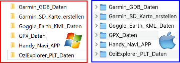 The Zip-File The Zip-File (MDMOT_All_GPS_Data__xxxx.zip) contains various GPS formats such as GPX/PLT/KML/GDB), these are stored in compressed form in the file so that the file size is smaller and can therefore be downloaded more quickly from the Internet. The ZIP file can be downloaded to a MAC/Windows PC and then unzipped if necessary. The following folders with the GPS data should then be visible on the hard drive. |
|
| Garmin_GDB_Data: This folder contains a GDB format file containing all tracks/routes/waypoints. If you want the GPS data individually, you can find it in the GPX_Data folder (click here for more info).Garmin_GDB_Data:This folder contains a GDB format file containing all tracks/routes/waypoints. If you want the GPS data individually, you can find it in the GPX_Data folder (click here for more info). |
|
| Create Garmin SD card: This folder contains all the files needed to create a microSD card, which you can then insert into your Garmin device or BMW Navigator and use for navigation. (Click here for more info)Create Garmin SD card:This folder contains all the files needed to create a microSD card, which you can then insert into your Garmin device or BMW Navigator 4,5,and 6 and use for navigation. (Click here for more info) |
|
| GPX_Data: This folder contains many GPX files for various navigation systems or to convert to your own format. These include POI/waypoint tracks and individual tracks. (Click here for more info)GPX_Data:This folder contains many GPX files for various navigation systems or to convert to your own format. These include POI/waypoint tracks and individual tracks. (Click here for more info) |
|
| Handy_NAVI_APP: For a navigation app (third-party provider) we offer GPX data for import, these are located in the GPX data folder. |
|
| OziExlorer_PLT_Data: This folder contains tracks in PLT and POI/waypoints in WPT format, e.g.Ozi Explorer files are still very common in off-road navigation systems. Some are Navigator or 4x4 Globe.Important: In the OZI-Explorer folder there is a small documentation (G) about OziExploerer files using the example of the navigation device Navigattor., |
|
| Garmin_GDB_Daten: This folder contains all files in GDB format (routes/tracks/POIs/waypoints). These can be imported via Garmin Basecamp or Garmin Explore, for example, and transferred to the navigation system. |
|
| Garmin Basecamp: Free Garmin program for MAC/Windows where you can import/plan GPS data and then transfer it to your Garmin navigation system. Download Basecamp for Windows/MAChttps://www.garmin.com/de-DE/software/basecamp/ |
|
| List of Garmin devices compatible with the Garmin Explore.https://support.garmin.com/de-DE/?faq=o2VcUgraJX4twZzO1ME7z9 | |
| Garmin_SD_card_create If you own a Garmin device, you can also create a micro SD card with our GPS data on a Windows/MAC PC/laptop and then insert the micro SD card into your Garmin device. The prerequisite is that the micro SD slot on your Garmin navigation device is still free. A short instruction manual is located in the folder "Garmin_SD_Karte_erstellen". |
|
| KML General The KML_Files (D) folder contains several files that can be viewed in Google Earth, for example. KML is also one of the standard GPS formats used by some navigation systems and mobile apps. |
|
| Google Earth: We've usually stored the routes in KML format. This can also be accessed with Google Earth to get an overview. |
|
|
|
| The GPS data for downloading is included in the order confirmation you received after placing your order. The GPS data will be activated after payment and can be downloaded by clicking on the links (see (A)). |
|
 |
Become a 4x4 Europe Marathon Master:
It is a marathon off-road challenge where certain places on our off-road routes are approached. We call these places marathon points.
These marathon points can only be found in our 4x4 Europe Roadbooks. There is a marathon point for each off-road route in the book.
The aim is to collect as many of these points and become the Marathon Master for the respective country/region.
How does the 4x4 Europe Marathon work
Step 1 (prerequisite for taking part in the marathon):
Order a start number for the marathon in the online shop. You will be registered with us and then receive 2 large and 2 small start number stickers (example NR 99). Order your start number (click here). You only need the start number once and can then drive several marathons.
Step 2: Buy a 4x4 Europe Roadbook book/ebook, it contains all marathon points for the respective region/country.
Step 3: There is an option for each book (incl. participation in the marathon), there is a small processing fee for managing the points and the ranking.
Step 4: You drive on an off-road route from the 4x4 Europe Roadbook, e.g. B. Bosnia and come to a marathon point. You snap a photo of the marathon point and send us the photo with your start number.
Collect the marathon points, the table (in the book) where you can enter a note also serves as a little help.
Step 5: Send us all the photos of the points by email or WhatsApp, stating the start/participant number.
Step 6: We check the points and you are listed as a marathon master on our ranking lists (information on ranking lists is available at www.mdmot.de/de/marathon-ranking).
Step 7: We will send you 2 "Marathon Master" stickers and a certificate.
| You can select an MDMOT tour APP as an additional option in the online shop |
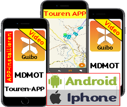 Guibo (MDMOT tour APP) We now have an MDMOT touring APP called "Guibo". There you can download our tours and follow them. The APP can be used with Android or Apple (iPhone) phones or tablets (with GPS receiver). |
|
Procedure: |
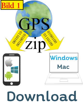 A download ZIP file is included A download ZIP file is includedThere is a ZIP file with GPS data in different formats (GPX, TRK, GDB ...) for different navigation systems. |
| General for ZIP-File (GPS-Data): In the online shop www.mdmot.de you have the possibility to order a book and as an option to get the GPS data as a download. If the article has been paid then the download will be activated.You will receive an email after unlocking with the download link of the GPS data. The book will be sent to by post at the same time. Important: The download does not include electronic books or route descriptions, there are the GPS data available as ZIP -File download as our CDs or USB sticks. After the release you have 4 attempts to download the data, then the download is locked again. Advantage: You can also trigger the download directly from a tablet or smartphone. |
| Small video about the functionality of the APP |
USB Stick Englisch
| You can select the download of the GPS data for the book as a download file in the online shop as an additional option. |
|
|
The GPS data for downloading is included in the order confirmation you received after placing your order. |
|
GPS CD Englisch
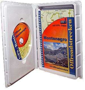 |
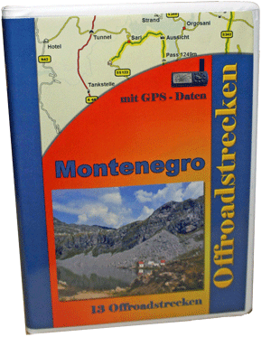
General: Optional on our books, there is a storage box, this one can keep the book, a disk and the supplement. In the picture is shown as an example of Montenegro with a CD. |
|
Box:
The box is ideal to be placed in a bookshelf. The box has check the dimensions: |
 |
 |
 |
 |
|
MDMOT SD + MicroSD card |
|
General infomation: We have also always the entry points on our CD's so that you can choose to navigated by the navigator to an entry point route, then the overlay route begins. Worth knowing about overlay routes 5. As selection there are camping and entry points as well as a number of categories. We choose the category entry points. |
 |
 |
 |
3. In the detail view you can now see a straight line route, and there is also indicated an overlay route (red). As you can well see the vehicle is located directly on the route, the air line route deviates, one always knows whether one is still on the right track. |
What is the maximum memory card size for my device?
The maximum memory card size, please refer to the following table. The data refer to the latest firmware version.
Only Garmin device supports SD card or Micro SD card.
Garmin - be DataCart not supported.
| Area | Modell | Memory Card used and maximum capacity |
| OUTDOOR | Monterra | 32 GB Micro SDHC card |
| Montana Serie | 8 GB Micro SDHC card | |
| Oregon 200/300/400(t)/450/550(t) | 4 GB Micro SDHC card | |
| Oregon 600/650(t) | 32 GB Micro SDHC card | |
| Dakota Serie | 4 GB Micro SDHC card | |
| Colorado 300 | 4 GB Micro SDHC card | |
| Astro 220/320 | 4 GB Micro SDHC card | |
| eTrex 20 / 30 | 8 GB micro SDHC card | |
| eTrex Vista HCx | 2 GB Micro SD card | |
| eTrex Legend HCx | 2 GB Micro SD card | |
| eTrex Vista Cx, Legend Cx, Venture Cx | 2 GB Micro SD card | |
| GPSMap 60Cx | 2 GB Micro SD card *1 | |
| GPSMap 60CSx | 2 GB Micro SD card | |
| GPSMap 62-Serie | 4 GB Micro SD/SDHC card | |
| GPSMap 64-Serie | 32 GB Micro SD/SDHC card | |
| GPSMap 76Cx | 2 GB Micro SD card | |
| GPSMap 76CSx | 2 GB Micro SD card *1 | |
| GPSMAP 176C | 128 MB Garmin Datacard | |
| SPORT | Edge 605 /705 | 2 GB micro SD card |
| Edge 800 / 810 | 8 GB micro SD card | |
| Virb / Virb Elite | 64 GB micro SD card | |
| Approach G3 / G6 | 4 GB micro SD card | |
| AUTOMOTIVE | nüvi 3xxx Serie | 16 GB micro SDHC card |
| Nüvi 22xx, 23xx, 24xx Serie | 4 GB micro SDHC card | |
| Nüvi 2xx5, 2xx7 | 16 GB micro SDHC card | |
| Nüvi 1xxx Serie | 4 GB micro SDHC card | |
| Nüvi 8x5 Serie | 4 GB micro SDHC card | |
| Nüvi 8x0 Serie | 4 GB micro SDHC card | |
| Nüvi 7x5 Serie | 4 GB SDHC card | |
| Nüvi 7x0 Serie | 4 GB SDHC card | |
| Nüvi 6xx Serie | 4 GB SDHC card | |
| Nüvi 550 | 4 GB micro SDHC card | |
| Nüvi 465 | 4 GB SDHC card | |
| Nüvi 3xx Serie | 4 GB SDHC card | |
| Nüvi 2x5W Serie | 4 GB SDHC card | |
| Nüvi 2x5 Serie | 4 GB SDHC card | |
| Nüvi 2x0W Serie | 4 GB SDHC card | |
| Nüvi 2x0 Serie | 4 GB SDHC card | |
| Nüvi 30/40 | 8 GB micro SD card | |
| nüvi 55, 56, 65, 66 | 16 GB micro SDHC card | |
| Nüvi 140/150 | 8 GB micro SD card | |
| Nüvi 5000 | 4 GB micro SDHC card | |
| zumo 210 | 8 GB micro SDHC card | |
| zumo 3xx | 16 GB micro SDHC card | |
| zumo 400 | 4 GB SDHC card | |
| zumo 5x0 | 4 GB SDHC card | |
| zumo 590 | 64 GB micro SDHC card (in FAT32 Format!) | |
| zumo 660 | 4 GB micro SDHC card | |
| BMW Navigator V | 64 GB micro SDHC card (in FAT32 Format!) | |
| dezl 560LT | 4 GB micro SDHC card | |
| dezl 760 | 16 GB micro SDHC card | |
| Camper / RV | 16 GB micro SDHC card | |
| StreetPilot i3 | 2 GB Micro SD card | |
| StreetPilot C3xx Serie | 2 GB SD card | |
| (bei Geräten mit SD-Steckplatz) | ||
| StreetPilot 7xxx Serie | 2 GB SD card | |
| StreetPilot 2610/50 | 1 GB Compact Flashcard | |
| StreetPilot III | 128MB Garmin Datacard | |
| iQue 3000, 3200, 3600 | 2 GB Micro SD card (no high-speed) | |
| iQue M3, M4, M5 | 2 GB SD card (no high-speed) | |
| MARINE | GPSMAP 172/178C | 256MB Garmin Datacard |
| GPSMAP 292/298C | 512MB Garmin Datacard | |
| GPSMAP 3005 | 512MB Garmin Datacard | |
| GPSMAP 3006 | 512MB Garmin Datacard | |
| GPSMAP 3010 | 512MB Garmin Datacard | |
| GPSMAP 2000 Serie | 128MB Garmin Datacard | |
| MOBIL | nüvifone A50 / M10 | 32GB SDHC card |
Shop List
| 0 Products | - | 0.00 EUR |
| Go to cart | ||
Onlineshop (EN)

We have 196 guests and no members online
- Articles View Hits
- 20316314